2005: Alberta Crown Land Disposition Mapping (DIDs)
The Challenge
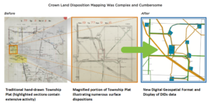
In 2004, there were 232,000 dispositions in the province. Surveys for these dispositions were submitted in a variety of paper-based and digital formats, and there was no digital spatial representation or map display. A single, coordinated initiative was needed to load and manage submitted surveys or sketches for all Crown land dispositions in Alberta.
The Solution
MNC built the Digital Integrated Dispositions (DIDs) mapping dataset for the Province of Alberta. MNC continues to maintain this dataset today…19 years later and over 435,000 Crown Land disposition plans integrated. MNC used Autodesk (AutoCAD), Bentley (MicroStation), Safe Software (FME), and Esri (ArcGIS) to create and maintain this data.
The Results
All 232,000 historical disposition plans were digitally drawn, compiled and integrated on time and on budget.


