Webinar Directory
End-to-End Land Record Management Solution for Illinois Counties
Modernize parcel management, streamline plan review, and secure your County’s land records roadmap — with Esri + MNC.

MNC and Esri — trusted by governments across the U.S., Canada, and the Caribbean.
Event Details
- Date: June 11, 2026
- Time: 10:00 – 11:00 AM CT
- Format: Virtual | Semi-Live + Q&A
- Audience: IL State Counties
What You’ll Learn
In this one-hour session, you’ll discover how to:
- Understand the business case and ROI for moving from ArcMap to ArcGIS Pro Parcel Fabric
- How to get more out of your existing ArcGIS Pro Parcel Fabric investment
- How Digital Plan Submission tools eliminate manual bottlenecks
- How ArcGIS Workflow Manager can orchestrate your entire operation
- Real-world results from a county that’s modernized to the ArcGIS Pro Parcel Fabric
- What your next step forward looks like
Receive:
- ArcGIS Pro: Low-cost Data Readiness Assessment
- Workflow Manager: Workflow Assessment
- Digital Plan Submission: Demo and data analysis
- Walk away with practical next steps
Proven Results
Real County Results: From Backlog to Efficiency
Hear directly from a county that has successfully modernized their land records system using Esri technology.
- Reduced plan review turnaround times
- Improved data confidence
- Reduce manual work
- Built a scalable, future-ready system
This is a real-world example of what modernization looks like in practice — and what your county can achieve.
Meet the Speakers

Elizabeth Greaves, Esri
Solution Engineer
With expertise in GIS and enterprise solution design, Elizabeth partners with public sector organizations to plan, configure, and deploy geospatial systems that support critical operations and long-term data strategy.
LinkedIn
Lauren Lee, Whiteside County, Illinois
GIS Director
Lauren has nearly 20 years of experience supporting local government through geospatial solutions. Her work focuses on parcel management, developing web mapping applications that improve data access and decision-making, and providing GIS services to multiple county departments.
LinkedIn
Matt Fisher, MNC
Director of Business Development
Extensive background as a Business Analyst and solution designer, helping clients turn complex modernization goals into practical, actionable outcomes.
LinkedIn
Heather Campbell, MNC
GIS Lead
10+ years in ArcGIS Pro and Parcel Fabric. Specializes in cadastral mapping, survey and title interpretation, data modeling, QA/QC, and CAMA/Tax integration.
LinkedInReserve Your Spot


Esri Gold Partnership, SLG and PF specialities
MNC makes modernization simple, accurate, and stress-free — one county at a time.
Land mapping leadership since 1998, MNC is proud to be:
- An Esri Gold Partner with Parcel Management Specialty, State and Local Government Specialty, and a recognized leader in parcel fabric modernization with GeoAI solutions
- A Safe Software Authorized Partner and FME® Solution Provider
MNC Esri Storymap | MNC Digital Plan Submission Videos
Learn more about MNC’s digital transformation projects.
Contact: webinar@silvacom.com
Modernizing Parcel Management Without Disruption: Lessons from Pacific Northwest Counties
Inaccurate or mismatched parcel data can create downstream problems across assessment, taxation, and land records systems. This session will share highlights from a Pacific Northwest County that has modernized and offer a preview of ArcGIS Online updates relevant to parcel management.

MNC and Esri — trusted by governments across the U.S., Canada, and the Caribbean.
Event Details
- Date: May 27
- Time: 10:00 – 11:00 AM PT
- Format: Virtual | Semi-Live + Q&A
- Audience: County and borough staff across WA, ID, and AK
What You’ll Learn
In this one-hour session, you’ll discover how to:
- Improve parcel accuracy and reduce misalignment between land and tax systems
- Reduce workflow bottlenecks and manual rework
- Migrate from legacy systems to modern GIS without disrupting daily operations
- Get a practical look at the new ArcGIS Online tools for modern parcel workflows
- See what a modernized county gained in efficiency, accuracy, and service
- Walk away with practical next steps
Proven Results
PNW counties are already seeing results like these:
- Improved parcel accuracy through topology rules and a history-aware data model that tracks parcel lineage over time
- Faster plan and deed integration — the new Parcel Fabric in ArcGIS Pro supports a record-driven workflow that reduces manual rework
- Better cross-department data sharing, so teams can work from a single authoritative dataset
- Reduced QA/QC burden through built-in validation tools
Meet the Speakers

Scott Wolter, Esri
Account Executive
25 years in GIS with deep experience supporting local government, modernizing land records, and delivering enterprise mapping solutions.
LinkedIn
Dan Stone, Esri
ArcGIS Parcel Fabric Product Manager
30+ years in land records and cadastral mapping. Dan works directly with the land-records community to ensure Parcel Fabric meets real operational needs.
LinkedIn
Matt Fisher, MNC
Director of Business Development
Extensive background as a Business Analyst and solution designer, helping clients turn complex modernization goals into practical, actionable outcomes.
LinkedIn
Heather Campbell, MNC
GIS Lead
10+ years in ArcGIS Pro and Parcel Fabric. Specializes in cadastral mapping, survey and title interpretation, data modeling, QA/QC, and CAMA/Tax integration.
LinkedInReserve Your Spot
No commitment required. This session is designed to help you understand your options.
Ready to Modernize Your Land Records?
Start small. See results. Scale when ready.
Join us to see how your county can modernize land records — without disruption.
No commitment required. This session is designed to help you understand your options.
MNC makes modernization simple, accurate, and stress-free — one county at a time.
Land mapping leadership since 1998, MNC is proud to be:
- An Esri Gold Partner with Parcel Management Specialty, State and Local Government Specialty, and a recognized leader in parcel fabric modernization with GeoAI solutions
- Safe Software Authorized Partner and FME® Solution Provider
- MNC Esri Storymap
- MNC Parcel Fabric Videos
Learn more about MNC’s digital transformation projects.
Contact: webinar@silvacom.com
Future-Proofing Ohio’s Land Data: How Counties Can Simplify Modernization with Esri and MNC
Learn how to migrate from ArcMap, improve workflows, and modernize parcel data using Parcel Fabric and MNC’s expert support.
Join Our Webinar
Across Ohio, county assessors, engineers, and surveyors face similar challenges: misaligned parcel, outdated workflows, data silos that slow operations, reduce accuracy, and limit collaboration.
This webinar reveals how Esri’s Technology and MNCs’ proven modernization services can simplify migration, improve workflows, data accuracy, and efficiency across county departments.
Why Attend
Discover how to make modernization simple, practical, and results-driven for Ohio counties!
In this session, experts from Esri and MNC will cover:
- How ArcGIS Parcel Fabric enables data driven decision-making
- What the ArcGIS Parcel Fabric is — and why now is the time to migrate before ArcMap retires in 2026
- How modern GIS tools simplify workflows, ensuring accurate, authoritative parcel data
- How MNC’s digital plan submission tools automate key workflows and save your county time
MNC’s Parcel Fabric & Modernization Expertise
MNC brings 25+ years of cadastral and modernization project experience across the U.S., Canada, and Caribbean.
As an Esri Gold Partner with Parcel Management Specialty accreditation, MNC helps governments:
- Migration to Parcel Fabric
- Workflow automation
- Staff training
- QA tools
- Cross-dept collaboration
- Real use cases
Case Studies
- Pasco County Florida Parcel Mapping — We turn CAD headaches into GIS-ready data you can design with
- Survey Plan Online Checker (SPOC) Modernization — Automated QA checks drastically reduced rejections and turnaround times.
- Plan Submissions Online (PSO) — Streamlined online plan approvals province-wide
- Alberta Cadastral Mapping — A foundation for more efficient, future-ready land management
- Alberta Land Title Mapping — Provides users with accurate land information province-wide
MNC makes modernization simple, accurate, and stress-free — one county at a time.
Land mapping leadership since 1998, MNC is proud to be:
- An Esri Gold Partner
- The only certified Parcel Management Specialty provider in Canada
- A recognized leader in parcel fabric modernization
- Safe Software Authorized Partner and FME® Solution Provider
Meet the Speakers
Jarod Fox, Esri
Solution Engineer
Jarod helps county governments across Ohio modernize GIS systems, streamline parcel workflows, and connect departments using ArcGIS technology.
LinkedInMatt Fisher, MNC
Director of Business Development
Drawing on extensive expertise as a Business Analyst and solution designer, Matt helps clients turn complex modernization goals into actionable, impactful outcomes.
Host: Leanna Chan, Silvacom VP Growth
Leanna will guide the discussion, connecting Esri and MNC’s technical expertise with the business outcomes that matter most to counties — revenue, efficiency, and trust.
Event Details
- Date: Nov 20, 2025
- Time: 9am
- Location: Virtual
- Format: Semi-live
- Audience: Ohio counties <100k pop.
Don’t miss this opportunity to modernize your land records. Join us to simplify your next steps and future-proof your county.


Contact: webinar@silvacom.com
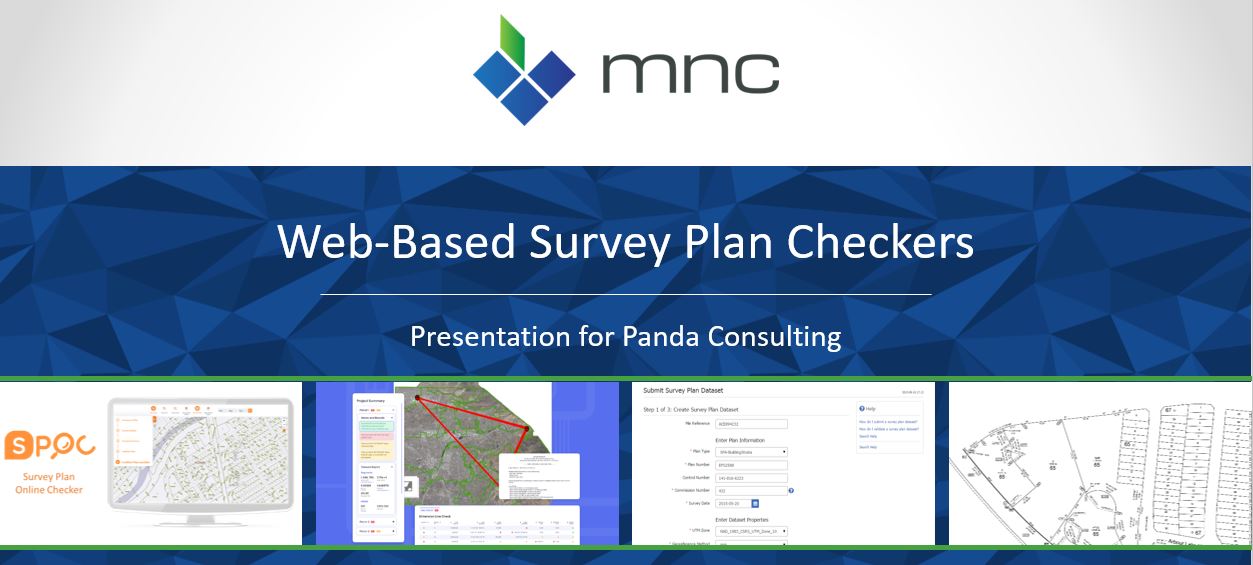
Bringing Efficiency to Land Administration via Online Survey Plan Submission Tools
Discover how government agencies and land professionals are transforming survey plan workflows using smart, automated digital submission tools — and unlocking massive efficiency gains.

Webinar Overview
Survey plans are central to land administration, but the validation and integration processes are slow, manual, and prone to errors, leading to backlogs. This webinar reveals how online digital plan submission tools improve speed, quality, and accuracy, saving land administration teams time and money.
Survey plan submission is a foundational step in land administration — yet for many municipalities, it remains a time-consuming, manual process that leads to delays, inconsistencies, and administrative backlogs. This FREE Webinar will explore how digital plan submission (DPS) tools are helping municipalities and land administration agencies modernize these workflows for increased efficiency, accuracy, and service delivery.
Request Webinar Access Now!
Why Attend?
In this session, experts from MNC and Esri will cover:
- What digital plan submission (DPS) tools are — and how they work (demo)
- Real-world success stories
- Common validation checks
- Integrating submission processes with ArcGIS Workflow Manager and Parcel Fabric
- Navigate the change with surveyors and land admin teams
What You’ll Learn
- How online portals make submissions easier for surveyors and plan checking teams
- Examples of automated QA/QC checks that reduce human error
- How ArcGIS Workflow Manager improves plan processing
- Tips for internal change management and stakeholder adoption
- Live demo insights and Q&A
Key Benefits of Attending
Learn how:
- A default specification for checking plans can get your organization up and running quickly
- Automated validations and approvals improve data quality and turn-around time
- Data integration workflows help land admin teams keep pace with submissions
- Streamlined workflows expedite processing times
Featured Speakers

Jill Urban-Karr
Sr. Business Development Manager, Land Administration, Esri
LinkedIn ProfileJill is a global thought leader in digital cadastre and government modernization. She has worked with agencies in over 40 countries.
“Bringing digital plan submission into the land administration workflow not only allows the surveyors to engage digitally with the Government, but also provides an automated standardized review process for all stakeholders resulting in accelerated response times, enhanced trust and increased transparency.”
– Jill Urban-Karr, Esri
Matt Fisher, CCBA, CGD
Director of Business Development, MNC
LinkedIn ProfileWith over 20 years of experience in vision, strategy and solution design for geospatial-based solutions, Matt is a seasoned expert who helps organizations harness the power of geospatial technology to solve real-world problems.
“Digital plan submissions are revolutionizing how land agencies operate. If you’re still doing manual validation — it’s time to see what’s possible.”
– Matt Fisher, MNC
MNC’s Digital Plan Submission Tool Expertise
- Automate plan validation
- Improve data accuracy and compliance
- Eliminate administrative backlogs
- Enhance data distribution
With over 25 years of land mapping leadership, MNC is proud to be:
- An Esri Gold Partner
- The only certified Parcel Management Specialty provider in Canada
- A recognized leader in parcel fabric modernization
- Safe Software Authorized Partner and FME® Solution Provider
FAQs
- How do I join? You’ll get the link in your confirmation email.
- Who should attend? Surveyors, GIS leads, land titles offices, municipal governments, and land management decision-makers.
- Can I share this with my team? Yes, please share freely with colleagues who would benefit.
For more information, please contact: matt.fisher@mncl.ca

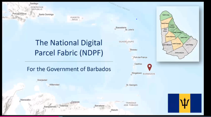
Watch Our Webinar on Realizing Efficiencies in Parcel Management
Learn how Barbados transformed land administration with a modern digital cadastre.
The experts from Barbados Lands & Surveys Department, Martin Newby Consulting Ltd., and Esri discussed how the National Digital Parcel Fabric (NDPF) project modernized land administration in Barbados.
What You’ll Learn
- How Barbados created a nationwide digital cadastre.
- The benefits of implementing Esri’s Parcel Management Suite.
-
Real-life case studies and project outcomes in economic development and
land tenure security.
Key Benefits of Watching
-
Discover how to modernize land administration with digital parcel
management.
-
Learn best practices for overcoming common parcel management challenges.
-
Gain insights from Barbados’ successful implementation of the NDPF
project.
-
Access expert advice from industry leaders in GIS and land management.


Webinar Overview
The National Digital Parcel Fabric (NDPF) for Barbados project was a collaborative effort between the Ministry of Industry, Innovation, Science and Technology (MIST), the Lands and Surveys Department, and Martin Newby Consulting Ltd. (MNC). The webinar focused on how this project transformed the land administration system of Barbados, creating a sustainable, nationwide digital cadastre that addressed both existing inefficiencies and growing demands.
Attendees learned about the tools, methodologies, and strategies used to create this digital parcel fabric and the project’s impact on land management, economic development, and future governance. Watch the video to discover how similar regions can leverage geographic approaches to streamline parcel management workflows and avoid common obstacles.
Barbados Creates a Digital Parcel Fabric to Modernize Their Land Administration
The Government of Barbados was seeking to modernize their Land Administration processes starting with the creation of a national cadastre, containing approx. 160,000 parcels. The project was the National Digital Parcel Fabric (NDPF) and the goal was to create a single, complete, trusted, and sustainable digital cadastre for Barbados using ArcGIS Pro. The presentation shares the journey of creating a nationwide digital cadastre in Barbados, featuring project insights, benefits, hurdles, and the Barbados user perspective within the Land Administration Modernization Program (LAMP).
“Collaborating with MNC has been an excellent process for Barbados Lands & Surveys. MNC’s project management and clear communication approach made it easy for us to evaluate options and make informed decisions. They were quick to problem solve and let us know the options and the impact of each.”
Michelle St. Clair, Project Lead of Barbados Lands & Surveys Department
Meet the Speakers:

Michelle St. Clair
Project Lead, Barbados Lands & Surveys Department
LinkedIn ProfileMichelle St. Clair is a Professional Land Surveyor who works with the team at the Lands and Surveys Department of Barbados to modernize and develop capabilities to empower all stakeholders to use GIS to solve national challenges that are related to land and the environment. With a background in land surveying, geosciences, and public administration, Michelle strives to improve workflows, foster collaboration, and put people first as Barbados uses data for better decision-making. Michelle is also committed to the empowerment of Small Island Developing States to bridge the digital divide through the use of geospatial information and technology.
Heather Campbell
GIS Lead / SME, Martin Newby Consulting Ltd.
LinkedIn ProfileHeather Campbell is a GIS Lead at MNC Ltd. She has been with MNC since 2015. Heather specializes in working with the ArcGIS Pro Parcel Fabric and ArcGIS Online apps. She is also skilled in the areas of data model design, quality control, documentation, training, team leadership for mapping projects, and project management.

Christopher Paquin
Business Development Partner Manager – Strategic Alliances, Esri Canada
LinkedIn ProfileChristopher is part of the business partner team at Esri Canada and focuses on developing alliances between Esri and third party organizations from the architecture, engineering and construction sector (AEC).
More Resources
Barbados – An Island Modernized