2020: Modernization of Survey Plan Online Checker (SPOC) for Alberta
2010 – 2020: About SPOC
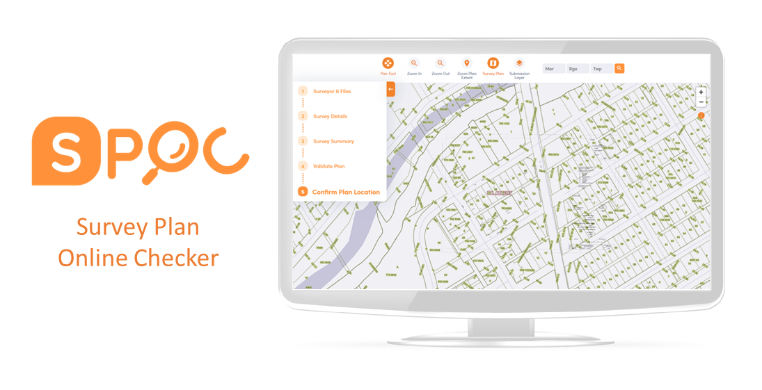
SPOC imports a CAD file and performs various business rule checks to validate its contents and formatting and then provides a package that is ready for submission to the LTO.
![]()
SPOC provides a means to perform layer checks to ensure the CAD files adhere to the required layer specifications thereby allowing LTO staff to focus on document registration rather than checking digital CAD files. There are three essential quality assurance functions:
- A layer content check provides the user with an acknowledgement that the submitted CAD file meets the required layer and element structure;
- The CAD file is processed through a geo-referencing quality check tool to ensure the CAD file is geo-referenced accurately and is consistent with the legal land description, projection and datum specified in the metadata; and
- A dimension check whereby line lengths are compared with their associated annotated dimension text.
Once these checks are complete, and if the file has met the quality requirements, it is uploaded to a map viewer. The user is then able to view their plan relative to the Alberta cadastral fabric to ensure the survey plan has been drawn in the correct spatial location. Once this has been verified, an email will be automatically returned to the user with the required files for Land Titles. It is a mandatory government requirement that all digital survey plans that are registered at Alberta Land Titles be processed by the SPOC application.
In January 2010, the Director of Surveys mandated that all plans submitted to LTO for plan registration were to be geo-referenced. All files are now processed through SPOC and verified that the digital CAD file is geo-referenced according to LTO requirements.

The Challenge
The SPOC browser technology used in the platform will no longer be supported on December 31, 2020; meaning that users will no longer be able to use SPOC and plans will not be able to be submitted to Alberta Land Titles Office. This will bring a halt to the current process to register plans at Alberta Land Titles Office.
Alberta Land Titles Office and over 400 Alberta Land Surveyors and their clients would be impacted.

The Solution
The original SPOC application was translated into modern technologies including Safe Software’s FME, Amazon Web Services (AWS), Freshdesk (by Freshworks), and a reconfigurable survey plan checker (SPC) API. The project was completed in 6 months.
The Results
Modernizing the SPOC platform directly addressed the risk of operating on an unsupported platform. The modernization provided a path forward to increase the longevity of the system.
In addition, the modern application mirrors the functionality of the previous application yet provides a better user experience; both of which limit the need for user training.
Modernized SPOC can perform plan checks, workflows and create plan packages that mirror current SPOC functionality.
The solution aligns with modern technology, API configuration and AWS integration supports plan checking. Cadastral web map integration supports improved currency.