Manitoba Hydro – The Property Parcel Fabric
Overview
A key GIS dataset created to enable the growth of GIS applications to support Manitoba Hydro’s Geospatial Data Services internal business units.
Business Challenge
Under the direction of Manitoba Hydro’s Geospatial Data Services, we set out to design, develop and compile a parcel base map conforming to Esri’s Integrated Cadastral Fabric data model from over 850 existing disparate parcel datasets that would provide Manitoba Hydro with an integrated and consistent parcel fabric layer – something no other single agency had ever accomplished in Manitoba.
Solution
As a first step, the project team of MNC and Esri Canada performed a Gap analysis to provide Manitoba Hydro with sufficient information to confirm the project requirements and direction. The objective of the Gap analysis was to identify where the source data sets from the City of Winnipeg, the Province of Manitoba, Natural Resources of Canada (aboriginal and park lands) and Manitoba Hydro’s internal archives, could and could not provide the required framework to support an Integrated Cadastral Fabric data model. The Gap analysis established a clear understanding of the data limitations, while reconfirming that the Integrated Cadastral Fabric model would be supported by the source datasets.
Tool Development – Building the Puzzle Repetitively
Manitoba Hydro’s Geospatial Data Services team selected FME (Safe Software Feature Manipulation Engine) as the software solution to provide a repeatable process for integrating datasets into the Cadastral Fabric. FME has the capability of transforming multiple data sources and formats in various ways. A suite of FME workspaces were developed to process source data:
- into a consistent structure
- with standardized attributes
- converting line strings to true circular arcs where applicable
- inversing and populating coordinate geometry attributes
- spatially improving source data to edge match with adjacent datasets
- topologically testing to ensure the Cadastral Fabric topology constraints were achieved
Each piece was transformed from their source state into an individual consistently formatted staging file geo-database. Utilization of the staging file geo-database provides an interim means of quality checking data prior to loading into the Cadastral Fabric while also allowing for flexible workflows, reprocessing either single or multiple source datasets or performing a complete provincial refresh.
20 unique workspaces were developed to manipulate the 850+ different data sets in a modular style. The processing of each unique dataset is controlled by database tables and invoked with the use of an overarching python control script. The control script populates ‘in/out’ feature counts, a status flag and a last run time stamp into a database table which provides a means of confirming at a glance that the workspaces completed successfully.
Once the staging file geo-databases were prepared, loading to the Cadastral Fabric was completed using ‘out-of-the-box’ ArcCatalog functionality. In order to enhance the load process with quality control and automation, a customized loader was developed. The customized loader populated ‘in/out’ feature counts and provided logging to ensure that the staging geo-database features successfully loaded into the seamless, provincial wide Cadastral Fabric.
Data Integration – Fitting the Puzzle Pieces
In total, over 850 datasets from the four source providers were ultimately integrated into the Cadastral Fabric. In some cases the data providers supplied known spatial accuracy statements, datums and projections; and in other situations the spatial accuracy and geo-referencing details became another puzzle to solve.
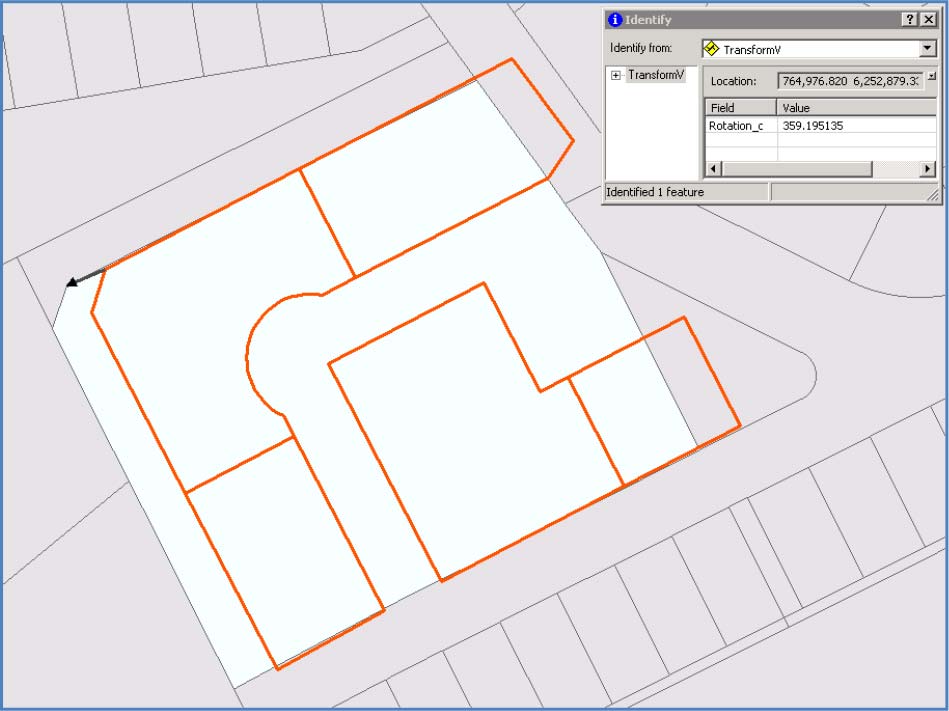
As an example, the spatial alignment of a particular site in north east Manitoba conflicted with the surrounding parcel data. 1:60,000 scale ortho-imagery was used to validate that this parcel dataset required a shift and rotation. To capture the required movement, a feature class called ‘TransformV’ was designed and populated with shift vectors. The custom ‘Transformer’ FME workspace uses this feature class to move and rotate the source data in an automated and repeatable transformation process.
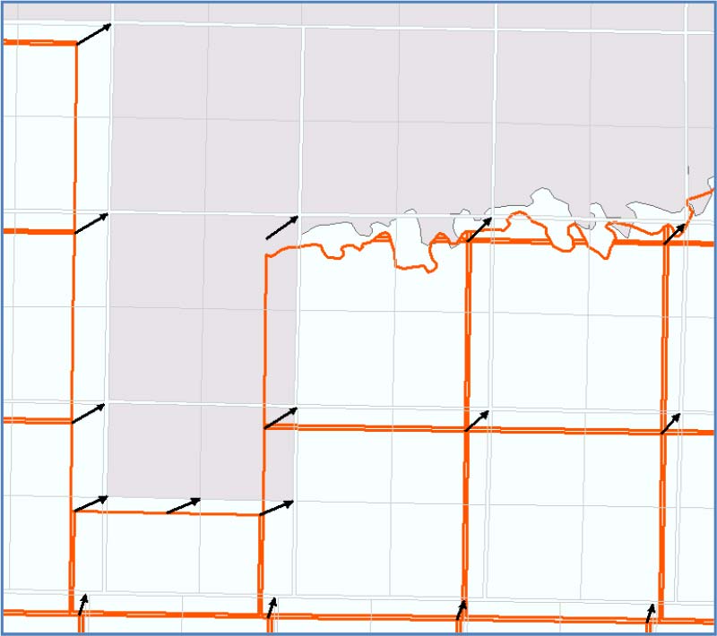
A custom ‘Adjustor’ FME workspace was built to address situations where adjustment algorithms are used to spatially conflate data and edge match with surrounding datasets. The source data required dramatic adjustment (over 800m) to better fit surrounding spatially accurate data. Once the data was conflated, then subsequent snapping FME workspaces were invoked to ensure that the vertices were coincident between adjacent data sets to satisfy topological requirements.
CAD data from Manitoba Hydro’s internal archives presented a unique challenge. Over the course of many years, these site specific survey drawings had been drafted using custom AutoCAD software and it was presumed that the content structure was uniform. However, a comprehensive data review revealed that various layer structures and standards were used that would require extensive effort to normalize. The extent of coverage also required validation as a number of the AutoCAD files covered similar or partially similar areas. In some cases, better alternate source data superseded the available CAD data. Initially over 500 AutoCAD drawings were reviewed and after correlating the coverage to other source datasets – only 310 files were deemed relevant. Of the 310 AutoCAD files, 60% generally followed a layer specification which left over 130 CAD files with inconsistent layers to be standardized.
Many of MNC’s custom batch programs and interactive tools provided an efficient means to clean CAD data from various topological and geometry issues such as: under-shoots, over-shoots, duplicates, zero length lines and invalid elements. Extensive manual cleaning effort was required in situations where line work was scattered amongst various layers. MNC’s and Manitoba Hydro’s Geospatial Data Services worked together to clean the CAD files to a consistent structure.
The Finished Puzzle
This key foundation GIS layer now provides Manitoba Hydro with an integrated parcel feature of over 1.5 million polygons. As the major energy provider for Manitoba, this single source, province wide, seamless and consistent parcel layer improves internal support of GIS applications and spatial decision making across all business units.
Benefits
- Ease of use: The Geospatial Data Services team is able to easily and readily maintain the fabric and the integration of new source datasets.
- Repeatable: The parcel layer can be updated easily on an as needed basis using a repeatable process that functions in a predicable way.
- Easy and convenient: Instead of referencing over 850 datasets to make a decision, Manitoba Hydro now has one single GIS parcel fabric layer.
- Improved quality: The seamless parcel fabric enables Manitoba Hydro to more effectively design power transmission networks and improve service delivery.
- Shared resource: Not only will Manitoba Hydro benefit from this project but this is a significant milestone for all surveying, mapping and GIS users in Manitoba; there is now a structured, homogenous Property Parcel fabric giving complete coverage of the province.
- Provincial-wide usage: The basemap will reduce duplication of parcel mapping efforts and costs for government and non-government organizations while also providing a foundation for collaborating with other organizations to build upon and add authoritative spatial data.