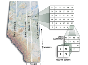
2005: Alberta Township System (ATS) Mapping
Any parcel of land in Alberta can be located by its legal land description, which are based on the Alberta Township System (ATS). In 2005, MNC upgraded the ATS mapping dataset to version 4.1 for the Province of Alberta using both Bentley (MicroStation) and Esri (ArcGIS) software.
The Challenge
Plans of surveys over the years provided updated coordinates of the ATS corners leading to the point where an adjustment of the Cadastral and the ATS fabric was required to minimize coordinate location differences between the mapping and GPS collected points on survey plans.
The Solution
MNC did an analysis of the ATS to the maintained cadastral fabric to identify the impact. It was agreed that a newer version of the ATS would be created and published to industry. MNC created Version 4.1 ATS in 2005 and the Alberta Government regulatory agencies mandated the use of ATS 4.1 for all regulatory submissions.
The Results
In 2005 the ATS 4.1 and the cadastral fabric were in sync which provided better accuracy for municipalities, utility companies and surveyors.


