2017: ParcelMap BC – Field CAD Tie Collection
Cadastral (CAD) tie collection was a key part of the PMBC project since Control (known locations on the ground) is the fundamental layer that supports:
- the fabric data model
- future spatial adjustments
- assessing spatial quality of the data, which is a core program requirement
![]()
Problems with Collecting Cadastral Ties using Traditional Survey Methods
Handling large volumes of paper prints in the field makes it hard to find the relationship between plans and proposed tie locations to the survey fabric.

The Challenge
Here were some of the challenges we faced:
- 94% of BC is Crown Land, covered by either mountains or forests.
- A tight timeline. Over 2,600 field ties had to be collected throughout the province in less than a year in order to stay ahead of the fabric compilation work.
- We started in September so the scheduling had to consider collecting ties only on Vancouver island or near Vancouver from November to February due to weather restrictions. The remainder of the province had to be collected after the snow melt.
- Parcel density of approximately one tie per 100 parcels had to be factored in.
- Ties had to be equally distributed across the geographic extent of the Province.
The Solution
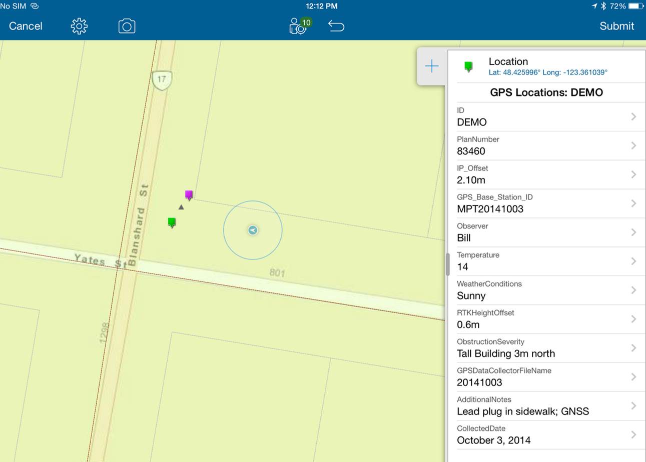
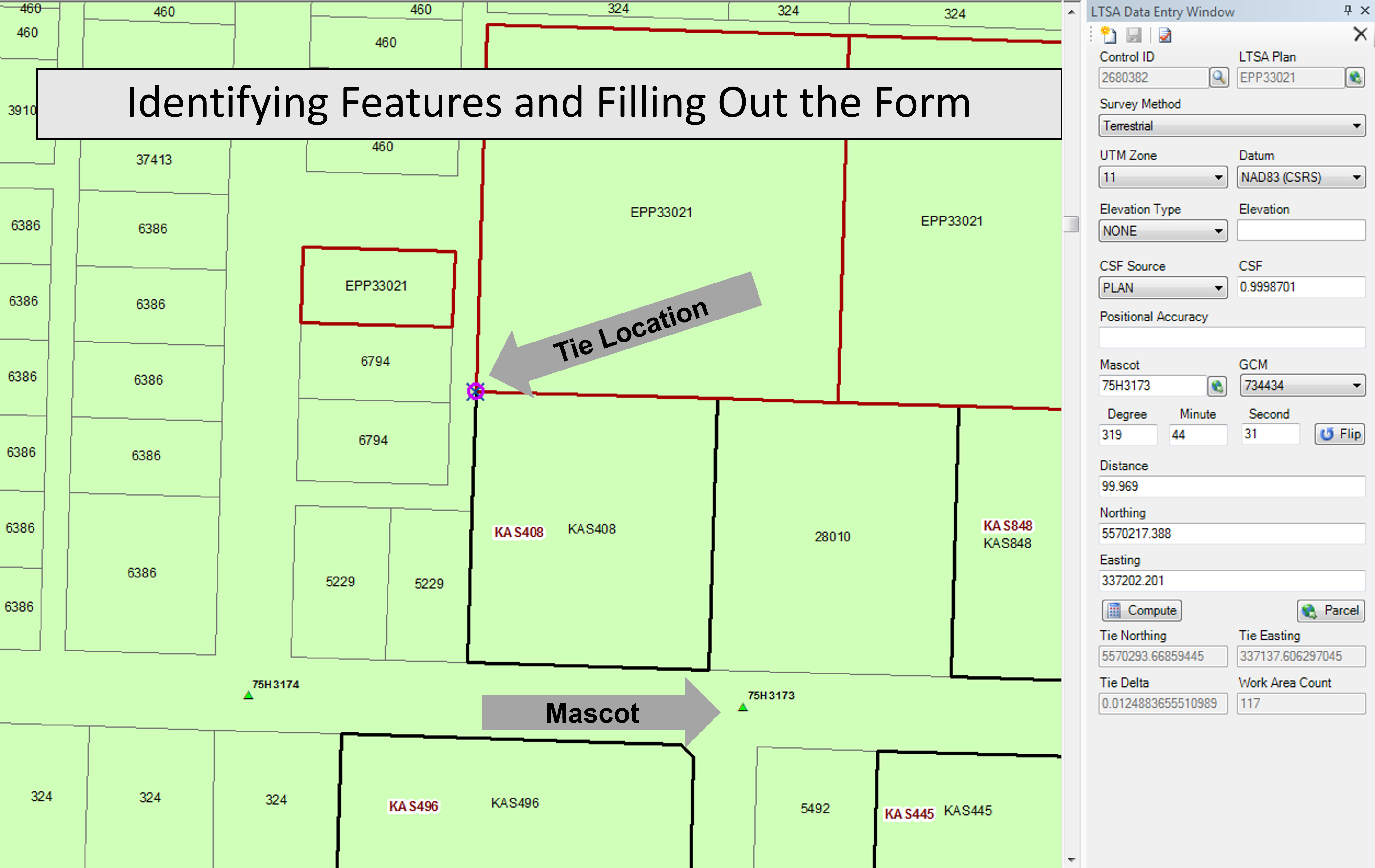
An efficient, affordable way was needed to collect, check, and manage the survey data. Therefore, we chose ArcGIS Online to manage the CAD tie planning and collection process. We leveraged the ArcGIS Collector tool to create an application we refer to as CATS (Cadastral Tie Survey) to augment traditional survey field methods. The application was built to collect survey-grade coordinates of field ties and images, in addition to using traditional GPS equipment.
The tool also allowed for red-lining to input details about a field tie. This tool had the ability to collect data for ArcGIS offline in remote areas and then upload the data when the field crews could re-establish a web connection.
Surveyor and field crews could collaborate in real time using ArcGIS Online to optimize the collection of over 2,600 field ties in a short timeline through the Province of BC
4500 Plan Ties and metadata were collected from survey plans in integrated areas in BC which was more cost effective than picking up ties in the field. All the ties were used in building the parcel fabric making it more accurate.
Field Work
In the field, surveyors did the following:Download planned points and work areas to iPad collectors
- Identify the point in the fabric
- Spatially locate the tie in the field and associate metadata to the point in the fabric
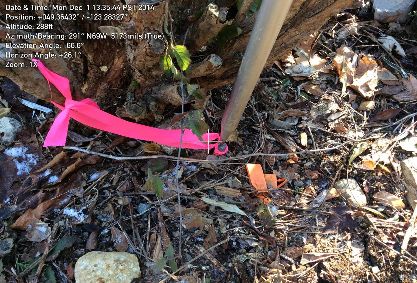
- Collect and associate images (registered plan and photo of the survey plan)
- Use coordinates from photos and coordinates captured in the app to validate the tie location
- Verify that coordinates picked up with the CATS application match within a tolerance to the accurate coordinates collected by surveyor GPS data collectors
Tolerance requirements were to have 5 cm positional accuracy in Integrated Survey Areas (ISAs), and 20 cm positional accuracy in all other areas.
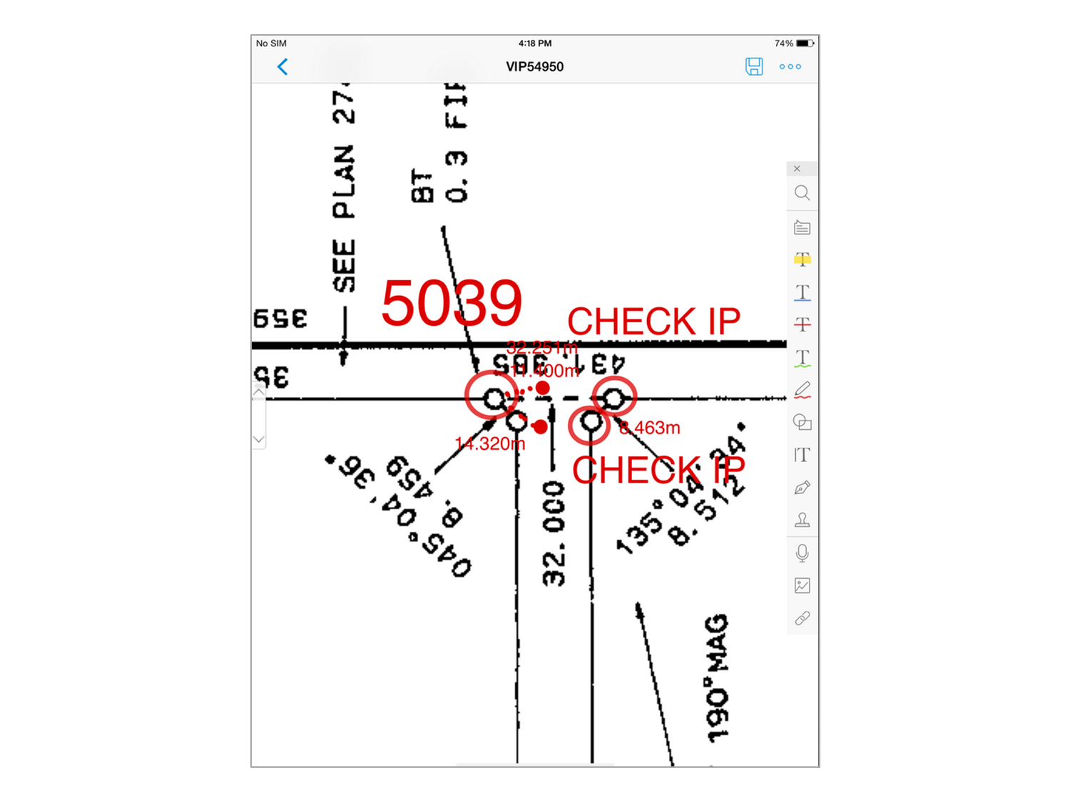
Planning CAD Points to Collect
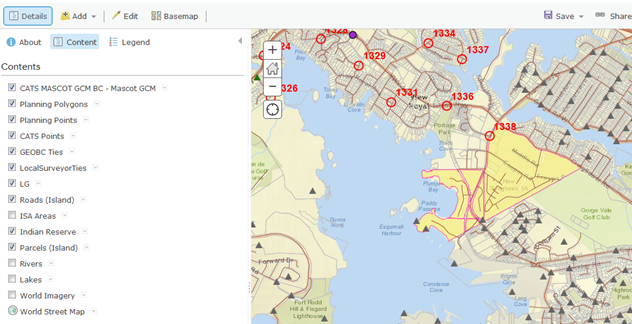
To be efficient our Surveyor pre-planned the points to be collected in the field using ArcGIS Online. If this same project were to be done again today, we could use Esri’s Navigator app instead.
Some considerations in planning the points were:
- Use “readily available” survey posts wherever possible
- Select block corners; there is a greater likelihood that a post will be found at one of the corners
- Ties will be collected only in areas with direct vehicle access
- Careful consideration was given for “open sky” to enable the use of GPS
- Imagery was used to identify clearings and to stay away from heavily treed areas
- Imagery also displays local improvements such as fences and roads which greatly assist in locating survey posts in the field
Field crew routes were pre-planned each day and MNC worked with LTSA to get approval on proposed field CAD tie locations.
Office Work
4,500 plan ties and metadata were collected from survey plans in Integrated Survey Areas (ISAs). This was more effective than picking up ties in the field. All the ties were used in building the ParcelMap BC parcel fabric, making it more accurate.
Office workers harvested monument points (MASCOTs) and tied them to parcel corners. All this was done within a customized interface created for ArcMap.
Becoming a Fan of ArcGIS Online
Our Surveyor was not familiar with GIS and had reservations about using ArcGIS Online. However, after planning the first collection area, he quickly realized the benefits:
- All reference maps and data were available on one map at his fingertips
- Ease of sharing data with field crews, interactively via the web
- Easily managed the field tie progress
- Data was uploaded, analyzed by the surveyor and backed up daily to prevent any loss of data
As Cadastral ties were being collected, the build of the parcel fabric began which would account for more than 2 Million active Titles in the province.
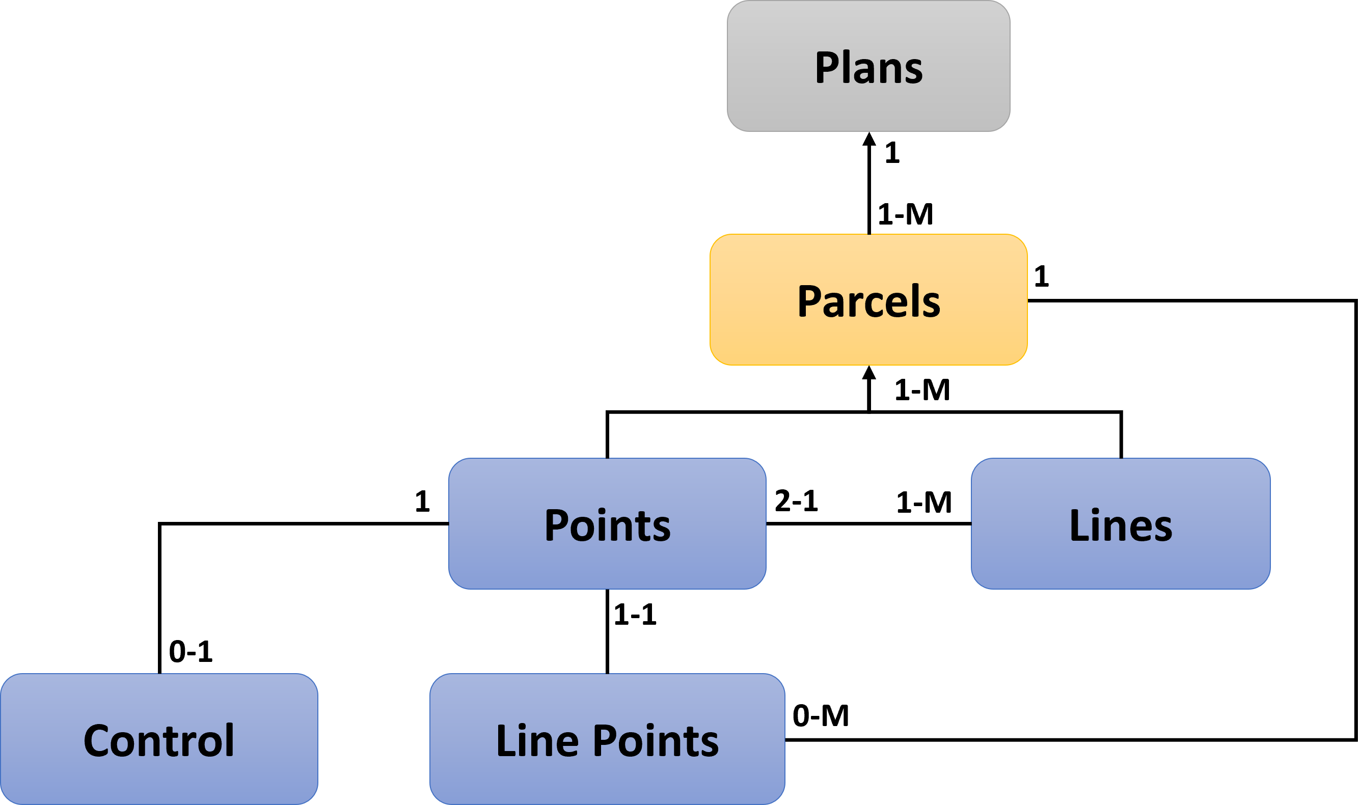
Elements of a Parcel Fabric
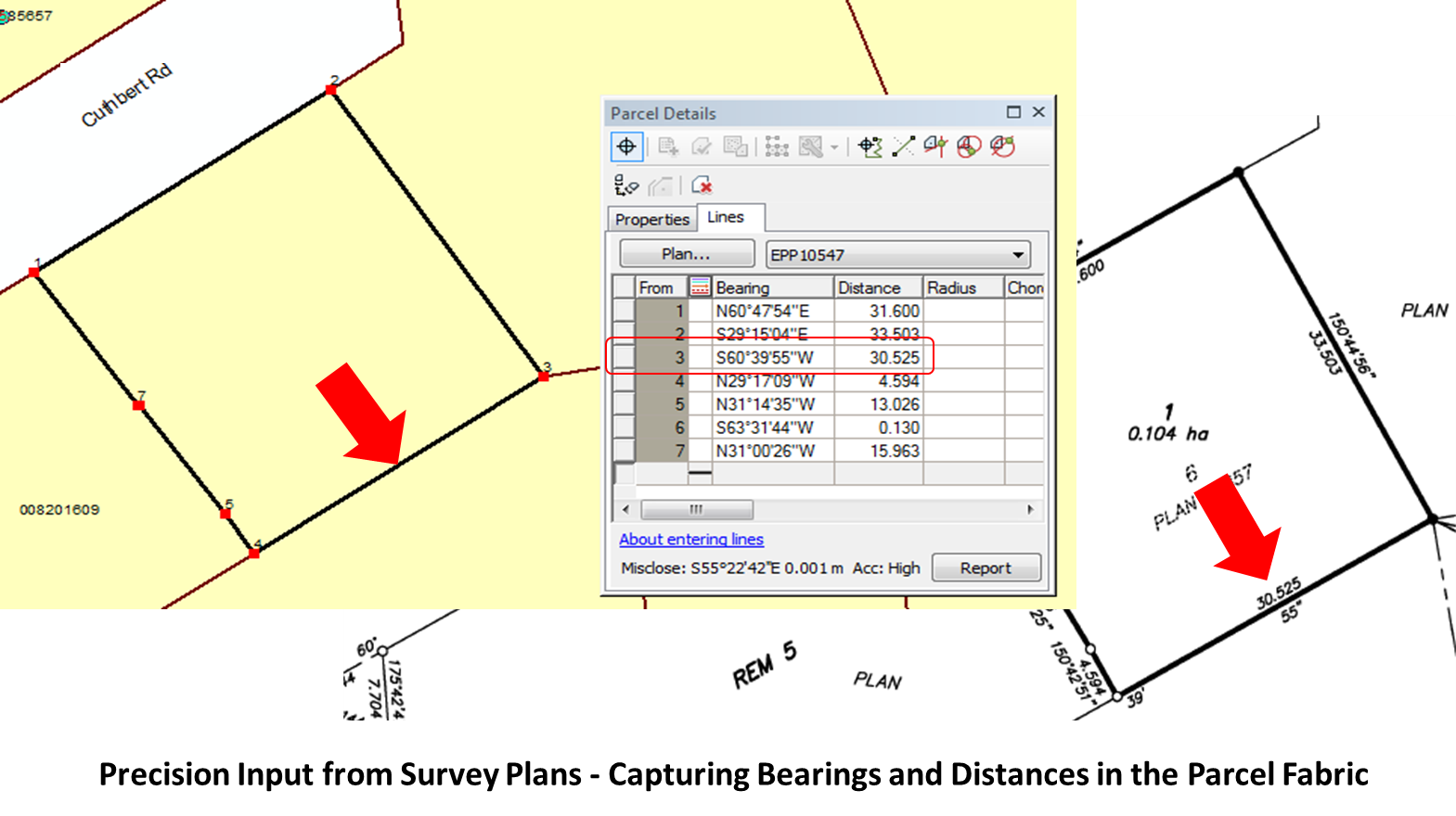
A parcel fabric maintains data integrity with relationships that persist between points, lines, and polygons. The “best” parcel fabric is one built from survey plans, whereby all observations (i.e., bearings and distances) are captured and retained.
The foundation of a parcel fabric is control (i.e., Cadastral ties) which represents known locations on the ground. Between points are boundary lines whose data structure allows the original surveyed observations to forever be retained on the geometry, no matter how the geometry is modified over time. These values are also used on adjustment algorithms for the fabric.
Acceptance Process
A Test Plan was developed to organize the testing and acceptance process for the ParcelMap BC parcel fabric. There were a total of 54 tests to ensure completeness and correctness. These included:
- Comprehensive tests either on an incremental delivery or on the whole provincial dataset, and
- Random samples for visual inspection.
The test plan ended up being more than 100 pages long. Structured test plans are common to software development and less common in data projects such as this. The benefit of having a test plan for the ParcelMap BC project was that it allowed for a rigorous, repeatable, and focused approach to consistently delivering high-quality data deliverables.
Data was delivered in several incremental deliveries throughout the project. Each increment contained approximately 150,000 parcels. The acceptance process involved each incremental delivery going through 3 sets of tests between 3 different groups:
- MNC: 2 weeks per incremental delivery – performing comprehensive and random sample tests
- MDA: 1 week per incremental delivery – testing the File Geodatabase to Postgres process
- LTSA: 3 weeks per incremental delivery – performing comprehensive and random samples tests
Safe Software’s FME
FME was integrated into the solution to perform the many tasks of loading, transforming, extracting, and checking that were required for the ParcelMap BC project. Parcel data was first loaded and modified into staging feature classes, which were then cleaned up and prepped for transformation into Esri’s Canadian Parcel Data Model (CPDM). The newly-created parcel fabric was then checked with a variety of quality-assurance tests.
FME was used in the following ways:
- To Create Fabric-Ready Data
- Aggregate polygons.
- Generate staging polygons and staging lines to be used in the parcel fabric creation process.
- Replace stroked curves in polygons with true curves.
- Check topology.
- Calculate the Combined Scale Factor (CSF) for each staging line using a Digital Elevation Model (DEM).
- Assign attributes to polygons and lines.
- Generate parcel fabric connection lines to support Least Squares Adjustment (LSA) functionality.
- For Acceptance and Testing
- Extract random samples.
- Verify completeness.
- Ensure correctness of attributes.
- Guarantee accuracy through data load and transformation.
WHY FME® WAS USED
- FME® is stable and reliable for handling very large datasets.
- Scripts are easy to re-configure leading to faster update cycles.
- In this multi-year project, data needed to be continually enhanced to keep up with current technology (i.e. data model updates).
- Ability to set up complicated data joins on multiple fields.
- Assigning attributes in FME® is much more time efficient than performing individual field calculations.
- FME® has specific transformations for issues encountered in PMBC.
- Checking for spikes, gaps, and overlaps in the parcel fabric is easier in FME®.
- Easy to de-bug scripts
- Log files are produced each time a script is run, and are easy to investigate.
- Outputs from each transformation can be analyzed directly within the FME® script canvas.
- The Inspector Transformer allows users to easily locate and de-bug issues; saving time and money.
- Testing is straight-forward and repeatable, and it is easy to prompt and run scripts.
- Data discrepancy outputs from tests can be formatted to simplify analysis.
- Scripts are scalable and can be run in multiple different environments.
- Users in different locations can run scripts on different systems (postgres or file geodatabase).

The Results
- Improve speed and efficiency of land-related research, planning and business decisions through a visual representation of the parcels in the land title register and Crown land registry.
- Minimize possible data discrepancies and confusion by reducing the need to consult separate spatial systems in BC.
- Supports faster and more accurate real estate dealings by using the visual representation of the parcels in the land title register.
- Reduces routine data maintenance tasks and overlapping parcel fabric efforts.
- Best Practices Compliant: completely adheres to the fundamental principles of a survey-aware fabric where all survey dimensions, and accuracies associated with the dimensions, are preserved and not altered.
- Comprehensive Integration: parcels are linked to their corresponding records in the Land Title Register and/or Crown Land Registry.
- This will allow users to conveniently access related parcel information such as titles, plans, documents, and tenure information.
- Survey-Aware Parcel Fabric: parcels are dynamically geo-referenced to the underlying provincial survey control network.
- This enables the overall parcel fabric accuracy to be continually improved as new geo-referenced survey plans are integrated into the fabric.
- New survey plans retain original survey observations, even after successive “best fit” adjustments have been made.
- Transparent Quality: each parcel within the parcel fabric has a known level of spatial quality.
- This will provide parcel fabric consumers with the information necessary to make informed business decisions.
- This will help target future spatial accuracy improvement programs by identifying areas of the fabric where spatial accuracy is poor.