

MNC Staff Member Earns Esri’s ArcGIS Pro Associate Technical Certification
Background
The Southern Alberta Institute of Technology (SAIT) provides work-integrated courses to students in the final year of their program. These courses allow students to participate in a semester-long capstone project; allowing them to work in multi-disciplinary teams on a real-life project with the support of a SAIT faculty member and member(s) of industry. The student’s work is then presented to all project stakeholders in a final presentation. The Bachelor of Geographic Information Systems (BGIS) program at SAIT offers such a course for its students.

MNC uses various GIS technologies including Esri’s ArcGIS suite of products. Two of Esri’s more recent product deployments are ArcGIS Workflow Manager and the ArcGIS Parcel Fabric for ArcGIS Pro. Workflow Manager is an Enterprise service providing organizations with end-to-end workflows that streamline tasks by automating and simplifying the performance and management of location-enabled work. The Parcel Fabric is a services-based GIS that provides a flexible data model that land administrators can use to maintain accurate, up-to-date, and authoritative parcel data. It’s an update of Esri’s previous parcel fabric which was developed for use within ArcMap. Since their deployment, MNC has been moving towards becoming subject matter experts with these new technologies.

Opportunity
During SAIT’s 2021 winter semester, MNC was selected to be a SAIT Capstone industry sponsor for two capstone projects related to ArcGIS Indoors implementations. For the 2022 winter semester, MNC had the opportunity again to submit a proposal to become an industry sponsor; this time related to the development is an “ArcGIS Workflow Manager – Parcel Fabric Data Integration” tool. MNC’s proposal was accepted and in January 2022 project work began.
Project Overview
Business Challenge
The process of integrating Land Interest Parcels into Alberta’s Crown Land Disposition fabric involves a complex set of repeatable, manual tasks. MNC wanted to evaluate the following: to what extent can ArcGIS Workflow Manager be utilized to manage and automate MNC’s parcel fabric integration process?
Objectives and Goals
The objectives were to utilize Workflow Manager to streamline MNC’s existing parcel fabric procedures, and to provide MNC with a deliverable outlining the approach, challenges faced, final outcomes, and recommendations.
To achieve this, the final goals included using the proof-of-concept prototype to incorporate and update the Parcel Fabric in two ways: using a file geodatabase, and using an Enterprise geodatabase which would enable branch versioning functionalities.
The SAIT Project Team
The SAIT team was comprised of SAIT students Kim Ambellar and Chad Harris, who were assisted by their instructor and capstone mentor Tigran Melkumyan. As the industry sponsor and project mentor, MNC engaged in regular meetings with the SAIT team throughout the project.
Project Work
Workflow
The SAIT team developed the prototype to adhere to a specific workflow, as outlined in the image below and described in the following steps.
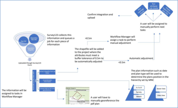
- A user opens a Survey123 form and enters in Disposition plan information. They also use the form to upload digital versions of the survey plan and plan shape
- Once submitted, Workflow Manager retrieves the information and initiates a parcel fabric integration job. The information is assigned to users in the form of tasks to be completed throughout the process
- The plan PDF is assigned to a user to be manually georeferenced to the integrated Disposition
- The plan information is used to determine the plan position in the hierarchy set by MNC; as newer plans will overrule older plans, and as-built plans will overrule survey plans which will overrule sketches as the parcel fabric develops over time
- The shapefile is uploaded and added to the project. It is then adjusted to integrate into the parcel fabric either automatically or manually based on the accuracy tolerance by an assigned user
- Once adjusted, users are assigned to run topology and attribute checks, and add a hyperlink to the plan PDF
- Finally, the integration is confirmed and uploaded as a new version of the parcel fabric
Setbacks and Solutions
One of the project goals included using the proof-of-concept prototype to incorporate and update the Parcel Fabric using an Enterprise geodatabase which would enable branch versioning. This Workflow Manager (Enterprise) service is accessed through ArcGIS Online when hosted and enabled on an Enterprise server. However, this was not accessible to the SAIT team at the beginning of the project because Enterprise was still under development for introduction into SAIT’s organization. During this time, the SAIT team developed their understanding of Workflow Manager (Enterprise), produced a Survey123 form for data collection, and developed the methodology shown above to be utilized once the team gained access Workflow Manager (Enterprise).
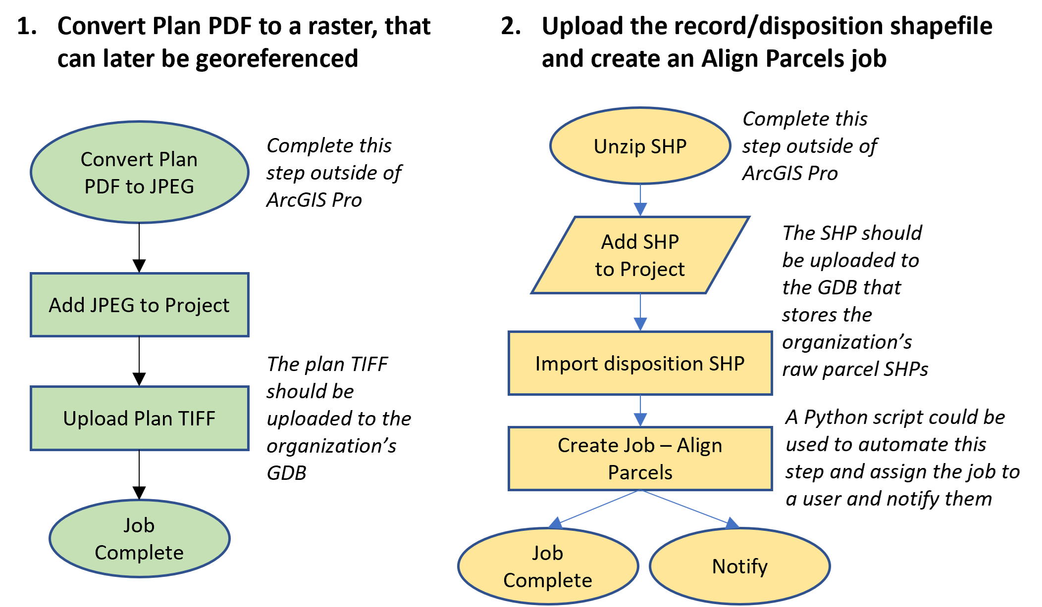
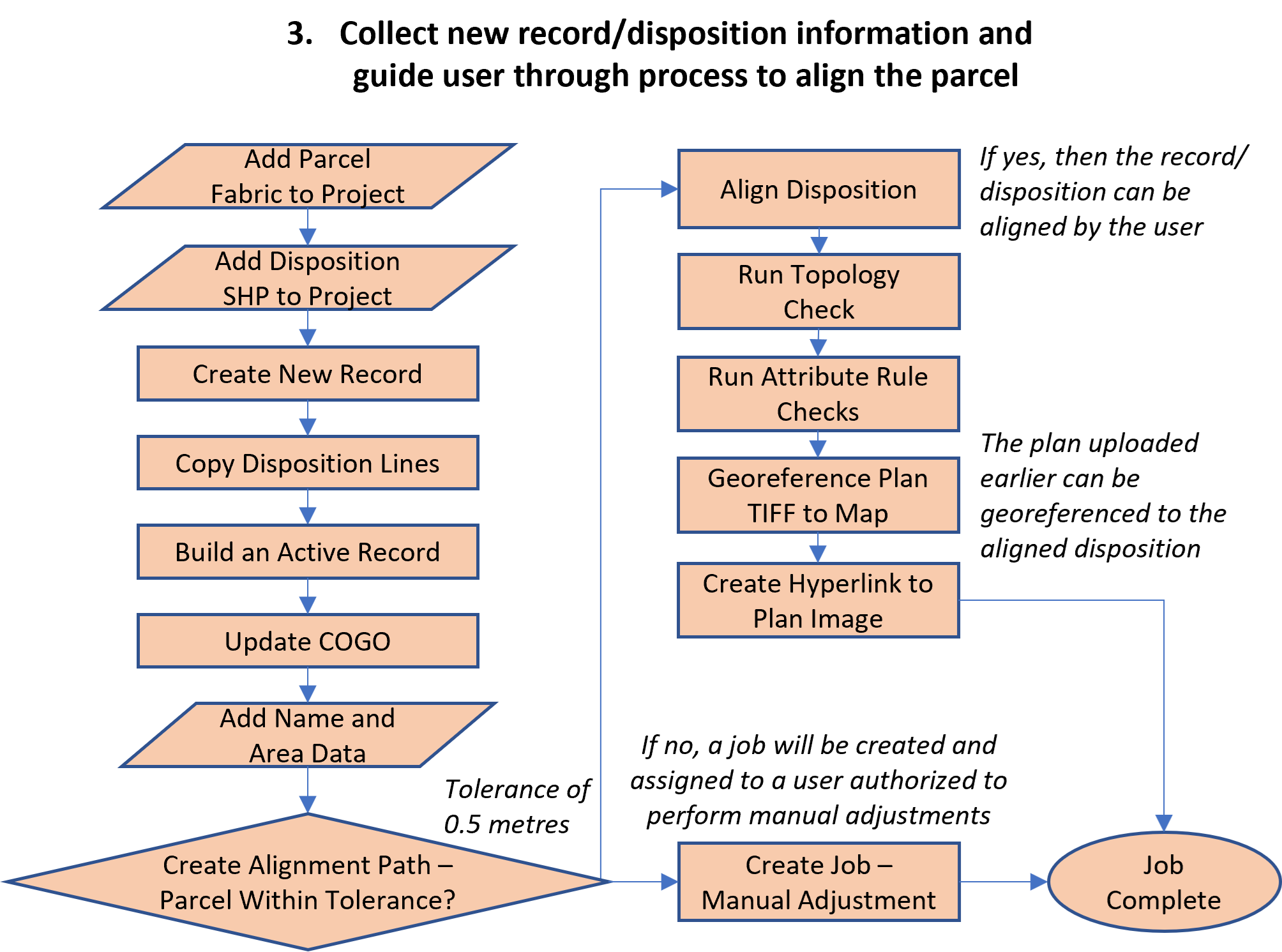
The team eventually learned that access to Workflow Manager (Enterprise) was not possible for this project. However, after discussions with the team instructor and MNC, the SAIT team decided to pivot to use the Classic version of Workflow Manager instead. This shift required a vast amount of back-end server initiation, but once completed the SAIT team determined that their original methodology could still be applied in the creation of steps, workflows, and jobs.
As a result, the team was able to create a prototype using Workflow Manager (Classic) that could create and manage jobs, though without any fully automated capabilities. The workflows developed are shown below.
Conclusions
The SAIT team concluded that there is potential to automate the Parcel Fabric integration process through using ArcGIS Tasks which could be written as individual Python scripts, but due to time constraints the team was not able to test this functionality.
At the end of the project, the SAIT team delivered a step-by-step process document describing how to set up Workflow Manager (Classic), as well as a detailed project report presented in an Esri Story Map.
Recommendations
The SAIT Team acknowledged that Workflow Manager (Enterprise and Classic) could potentially introduce more tasks and be counter-productive in terms of Parcel Fabric integration; especially since MNC’s team is already well-versed in the integration processes. However, the SAIT team ultimately recommended using Workflow Manager to help streamline tasks and make Parcel Fabric integration processes more efficient; especially once automation could be set up. They also highlighted that Workflow Manager could be a useful tool to onboard users not already familiar with MNC’s integration processes.
Lessons Learned
The team gained real-world experience through this project. They learned about back-end system administration, project management, and overcoming the setbacks of not having immediate access to all required software. This project ultimately allowed the SAIT team to become more adaptable and resourceful, which will serve them well as they move on in their GIS careers.
Links of Interest
Esri Story Map Project Report
SAIT BGIS Program
ArcGIS Workflow Manager Overview
ArcGIS Parcel Fabric Overview
LinkedIn Profile for Kim Ambellar
LinkedIn Profile for Chad Harris