2018-2023: Survey Consulting Services for Orange County, California
Since 2018, MNC has provided consulting services for Orange County Public Works on the County’s implementation of a digital plan checking system.

The Challenge
The County Surveyor maintains thousands of land and survey-related records within Orange County. Various business units require the checking or creating of land parcels from written Metes and Bounds (M&B) descriptions. Currently this process is manually intensive and error prone. The Orange County Surveyor needs external support to provide Consulting and Training for the automation of Geometry creation and Validation.
The Solution
Performing GIS and FME services, MNC provided:
- Consultation and recommendations for Best Practice Requirements for On-Line Survey Plan Submissions
- Consultation for the use of FME/Esri ArcGIS Data Interoperability Extension to perform data validation and translation between AutoCAD and ArcGIS
- As-needed application development and technical support for custom scripting that extends the base features of the FME/Esri ArcGIS Data Interoperability Extension
Parcel Checker
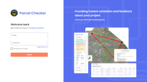
In partnership with Orange County, Silvacom CS developed the Parcel Checker application; a new survey plan-checking tool that revolutionizes how parcel checks can be automated. The Parcel Checker is a cloud-based system that surveyors use to test their files, in advance of submitting to Orange County staff. This saves cost and time in the approval process. The easy-to-use interface and simplified workflows result in an expedited process.

The Results
Through consultation, training, and the development of the Parcel Checker application by MNC and Silvacom CS, the project provided Orange County with efficient tools and workflows to ensure accurate and timely submissions of survey plans, ultimately saving time and costs in the approval process and reducing plan rejections.

