Background
The Southern Alberta Institute of Technology (SAIT) provides work-integrated courses to students in the final year of their program. These courses allow students to participate in a semester-long capstone project; giving them the opportunity to work in multi-disciplinary teams on a real-life project with the support of SAIT faculty members and members of industry. The student’s work is then presented to all project stakeholders in a final presentation. The Bachelor of Geographic Information Systems (BGIS) program at SAIT offers such a course for its students.
Wendy Amy, Project Manager at Martin Newby Consulting Ltd. (MNC), is a part-time SAIT instructor and BGIS graduate and as such, was aware that this course was offered. MNC is a geomatics firm based in Calgary, Alberta with more than 23 years of CAD and GIS experience in the areas of surface land mapping creation, migration, improvement, and maintenance. MNC uses various GIS technologies including Esri’s ArcGIS suite of products. One of Esri’s more recent product deployments is ArcGIS Indoors; a complete indoor mapping system for smart building management that includes an Indoor Space Planner web application for planning and managing indoor spaces. Since its deployment, MNC has been moving towards becoming an ArcGIS Indoors subject matter expert.
MNC is also part of The Silvacom Group of Companies™ which includes Silvacom Ltd. (Silvacom), whose head office is located in Edmonton, Alberta. Silvacom is a natural resource management company that provides professional services and develops cloud-based geospatial solutions for both private and public sector organizations with a team of approximately 80 full-time employees.
Overview
Business Challenge
Due to the global Covid pandemic, most Silvacom staff have been working from home. To plan for staff to return to work from the Edmonton office, Silvacom’s Vice President of Operations, Rick Reid, was looking for a flexible system that could assign office space to employees on a rotational basis once restrictions on returning to work were lifted.
Solution
The Indoor Space Planner web application provides enhanced methods to plan and maintain spaces, assign & un-assign spaces, and create office hotels. This is especially relevant during the Covid pandemic where social distancing and space planning is critical to creating a safe work environment.
With Silvacom’s need for a space planner application and MNC’s ArcGIS expertise, Rick and Wendy saw the opportunity to support both SAIT and the local geomatics community by becoming SAIT capstone industry sponsors. After reaching out to SAIT, in December 2020 the MNC-Silvacom team got to work preparing a proposal for the SAIT students and faculty members of the BGIS program to consider for a capstone project. The proposal was accepted and in late January 2021, a student team was selected to begin project work to create an Indoor Space Planner web application for Silvacom’s head office in Edmonton.
Project Team
The SAIT team was comprised of instructors, capstone mentors Tigran Melkumyan and Jamie Johnston-Stewart, and SAIT students Ugochukwu Iheanacho, Bashu Acharya, and Adeyinka Oridate.
MNC and Silvacom were industry sponsors and project mentors for this capstone project. Silvacom was the customer, providing the Business Requirements.
Scope
The scope of work for the SAIT team to develop the Indoor Space Planner for the Silvacom office was as follows:
- Prepare a project plan to execute and monitor the project
- Acquire the detailed space planner business requirements from the customer
- Create the Indoor Mapping data
- Design, build and test the web app solution
- Demonstrate to the customer the completed application
- Regularly meet with MNC via Microsoft Teams (Teams) to report on project status
- Hold a project close meeting to review lessons learned
Business Requirements
Early on in the project, MNC and Silvacom met with the SAIT team to refine the business requirements as follows:
- Show all Silvacom business units with different color codes
- Show list of employees and allow them to assign and unassign workspaces interactively
- Display when space is booked on the map
- Show spaces with the name of the occupants when assigned
- Show spaces that should not be able to be assigned (e.g.: kitchens, stairwells, etc.)
- Show which external customer is using a meeting room
- Design the application to be easy to operate (so users do not need to be GIS specialists)
- Design the app to monitor capacity (i.e. through a dashboard)
Project Work
The general workflow to create a Space Planner application is shown below.
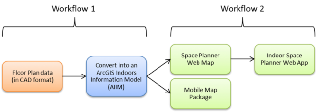
Workflow 1
For this project, Workflow 1 (shown in the general workflow above) was broken down into several smaller steps as shown below.
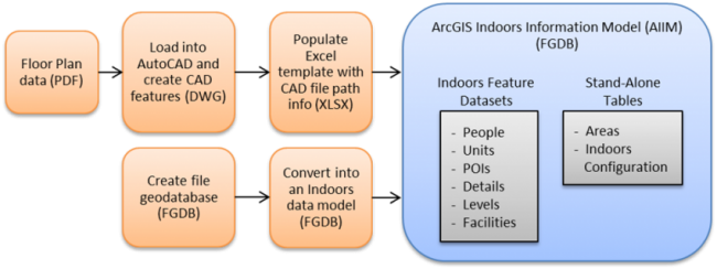
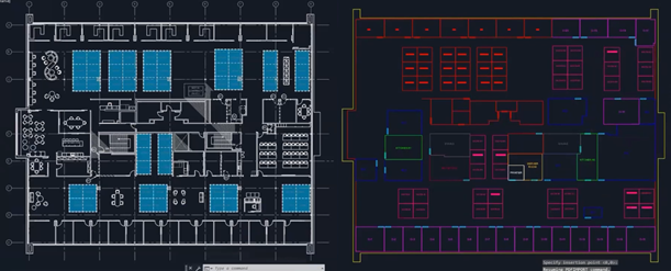
The source data used for this project was a PDF floor plan of the Silvacom office, provided by Silvacom. The SAIT team started by loading the PDF into AutoCAD (by Autodesk), where they used it to create and classify CAD linework and areas. The CAD data was saved as an AutoCAD file (DWG).
The CAD layer and file path information was then populated in an Excel (XLSX) Indoors information template provided by Esri, making it ready to import into the ArcGIS Indoors Information Model (AIIM) in a later step.
Meanwhile, in ArcGIS Pro, a file geodatabase (FGDB) was created and features were added for an Indoors Database model using the geoprocessing tool “Create Indoors Database.” The resulting FGDB contained empty feature datasets and stand-alone tables that provided the framework for the AIIM.
The Indoors information template (XLSX) and the empty Indoors data model (FGDB) were then used as parameters for the “Import Floorplan To Indoors Geodatabase” geoprocessing tool which created the final populated AIIM.
Workflow 2
The AIIM was then modified and used to publish several web layers, as shown in the breakdown of Workflow 2 below.
Prepare the Data
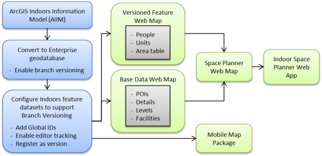
To prepare the AIIM data for the Indoor Space Planner so it could be made available to the public, the FGDB first needed to be converted to an Enterprise geodatabase. Branch versioning also needed to be enabled to allow the data to be editable.
Next, the Indoors feature datasets themselves needed to be configured to support branch versioning. This was accomplished through:
- Adding Global IDs;
- Enabling editor tracking; and
- Registering the data as a version.
The team noted later that making sure branch versioning was configured properly on the data was one of the most challenging aspects of the project and took quite a bit of time to accomplish. This was an important step however because it ensured that the final Indoor Space Planner web application functioned correctly.
Publish the Space Planner Web Map
To create the Space Planner web map, two separate maps first needed to be prepared and published from ArcGIS Pro. These were the Versioned Feature Web Map and the Base Data Web Map.
Versioned Feature Web Map
The Indoor feature datasets People and Units and the stand-alone table Areas were published together using the geoprocessing tool “Publish Web Layer.”
Base Data Web Map
The Indoor feature datasets Points of Interest (POIs), Details, Levels, and Facilities were published together using the geoprocessing tool “Share As Web Map.”
Publish the Mobile Map Package
All Indoor feature datasets and stand-alone tables in the AIIM were then published together using the geoprocessing tool “Package Mobile Map.” This created a map that could be accessed on mobile devices for use by the ArcGIS Indoors mobile apps, which allowed users to book spaces, including hotel spaces (available for short-term assignment).
Publish the Indoor Space Planner Web Application
Once the Versioned Feature Web Map and Base Data Web Map were shared to ArcGIS Enterprise, they were combined into a new Space Planner web map. After it was verified that the Space Planner web map and AIIM data had been configured properly, the Indoor Space Planner web app could be created. This was done by signing into ArcGIS Enterprise, browsing to Space Planner web map, and using the options to ‘Create a web app’ using the ‘Indoor Space Planner’ template.
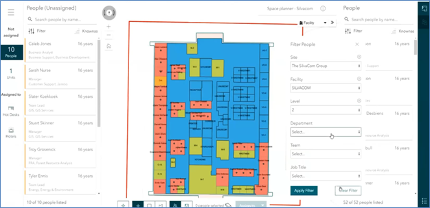
The published application shows a map of the Silvacom floor plan with assigned offices shown in red, unassigned offices shown in orange, hotel spaces available for short-term assignment shown in green and unassignable spaces not considered for this project shown in blue.
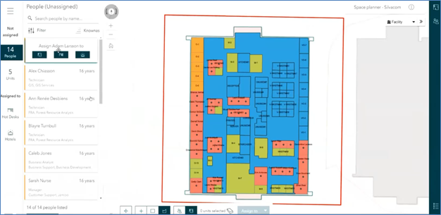
There are many ways to assign or unassign spaces within the application. An interactive selection tool for instance can be used to assign or unassign one or more spaces directly from the map. Employees (i.e. People) can also be assigned by dragging and dropping their name from the panel on the left into a space in the map, or by selecting their name from the panel and assigning them an office by name (e.g. O-5, M-4, etc.). Meeting rooms or other hotel spaces can also be assigned within the application in similar ways.
Filter tools are also available from a panel on the right to view certain employees/spaces based on certain attributes.
Future Enhancements
One of the features possible with Indoor Space Planner, though not implemented for this project, is the ability to sync booked meeting rooms with Microsoft Outlook so that booked times and spaces show up in employees’ Outlook calendars. Another such future enhancement would be to generate a network and create pathways and transitions to allow for Indoors navigation between offices and/or points of interest.
Summary
Project Output
The SAIT team completed their work for this capstone project and successfully delivered the following key outputs:
- ArcGIS Indoors Information Model (AIIM)
- Space Planner Web Map
- Indoor Space Planner Web Application (including a dashboard)
- Mobile Application
Project Validation
Validation steps were completed throughout the project to:
- Ensure accurate capture of PDF source data to CAD;
- Verify the presence of required data fields for the AIIM; and
- Review each milestone by holding review sessions with project stakeholders and technical experts.
Lessons Learned
At the end of this project, the SAIT team noted several lessons learned:
- This project solved a real-life problem by integrating geospatial and non-geospatial data
- Project management was used to optimize project workflows and success
- Utilizing a work breakdown structure (WBS) helped define accountability
- Engaging customers and technical experts regularly helped ensure project success
- Proper and consistent documentation of steps were needed throughout the project
Conclusion
The SAIT team delivered on the project Scope and Business Requirements set out at the beginning of the project and presented their work to stakeholders in April 2021. The BGIS capstone project effectively allowed the SAIT students to apply their knowledge and skills learned in the classroom to a real-world situation, and gain valuable work experience with members of industry and industry-leading GIS technologies.
MNC and Silvacom were grateful for the opportunity to participate as capstone mentors and would like to thank the SAIT students and faculty for their participation in this project.
Links of Interest
SAIT BGIS Program
Esri Indoors Mapping Overview
The Silvacom Group
LinkedIn Profile for Ugochukwu Iheanacho
LinkedIn Profile for Bashu Acharya
LinkedIn Profile for Adeyinka Oridate