Background
The Southern Alberta Institute of Technology (SAIT) provides work-integrated courses to students in the final year of their program. These courses allow students to participate in a semester-long capstone project; allowing them to work in multi-disciplinary teams on a real-life project with the support of a SAIT faculty member and member(s) of industry. The student’s work is then presented to all project stakeholders in a final presentation. The Bachelor of Geographic Information Systems (BGIS) program at SAIT offers such a course for its students.
Wendy Amy, Project Manager at Martin Newby Consulting Ltd. (MNC) is a part-time SAIT instructor and BGIS graduate and as such, was aware of this course offered. MNC is a geomatics firm based in Calgary, Alberta with more than 23 years of CAD and GIS experience in the areas of surface land mapping creation, migration, improvement, and maintenance. MNC uses various GIS technologies including Esri’s ArcGIS suite of products. One of Esri’s more recent product deployments is ArcGIS Indoors; a complete indoor mapping system for smart building management that includes the ability to navigate indoor spaces. Since its deployment, MNC has been moving towards becoming an ArcGIS Indoors subject matter expert.
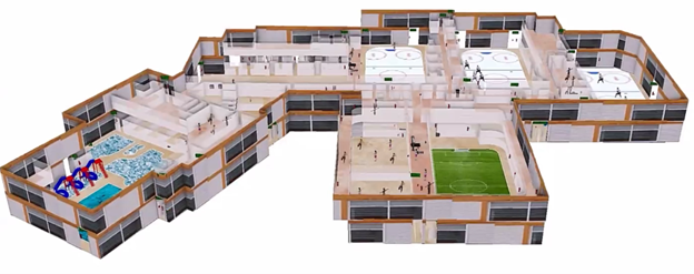
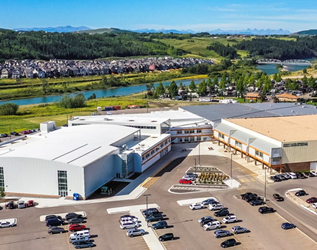
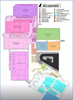
Ellen Styner, General Manager at MNC, learned that the Spray Lake Sawmills Family Sports Centre (the Centre) in Cochrane, Alberta was considering an indoor navigation application for its facility. The Centre is a 2-level, 350,000 square foot building that provides recreational facilities such as basketball courts, swimming pools, hockey rinks, and a fitness centre.
It was at this point that Wendy and Ellen saw the opportunity for MNC to support the Centre, SAIT and the local geomatics community by becoming a SAIT capstone industry sponsor. Representatives at the Centre were also willing to allow their facility to be the prototype for a potential capstone project, and a special thank you goes out to those at the Centre whose involvement made this capstone project possible, including Brooke Sabourin, Programs Manager and her team.
The next step was to reach out to SAIT, and in December of 2020 the MNC team got to work preparing a proposal for the SAIT students and faculty members in the BGIS program to consider for a capstone project. MNC’s proposal was accepted and in late January 2021 project work began.
Project Overview
Business Challenge
One of the main reasons that an indoor navigation app was being considered at the Centre is because the Centre itself is very large and has an irregular shape, making for difficult navigation. To give some context to the building’s size, it has nearly 80 emergency exits!
Solution
The ArcGIS Indoors platform allows users to navigate through indoor spaces and between floors via the application when it is loaded on a mobile device such as a phone or tablet. The SAIT team created a project plan for creating the indoor navigation application of the Centre and presented it to MNC.
Work began on the development of the application once the project plan was approved. The SAIT team was comprised of instructors and capstone mentors Tigran Melkumyan and Jamie Johnston Stewart, and SAIT students Kristine-Daniela Sheperdson, Luis Gonzalez Garcia and Luisa Trevisan Ribeiro (aka KLL GIS Solutions). As the industry sponsor and project mentor for this capstone project, MNC engaged in regular meetings with the SAIT team throughout the project.
Project Work
Source Data
One of the challenges associated with this project was data availability since there was no CAD or GIS floor plan data for the team to start building the application with. Instead, PDF floor plans were made available via MNC, and the team was able to collect digital Point of Interest (POI) data at the Centre using the ArcGIS Collector app for field data collection.
Scope
The scope of work to develop the ArcGIS Indoors navigation app for the Centre was as follows:
- Acquire source data from MNC (i.e. floor plan PDFs)
- Use both AutoCAD and ArcGIS Pro to create the ArcGIS Indoors data
- Categorize POIs collected using ArcGIS Collector
- Build a 3D Viewer of the building floor plan with Network Modelling and Path Analysis
- Build a Web App for the ArcGIS Indoors data
- Build a Mobile App for the ArcGIS Indoors data
Workflow
This diagram illustrates the overall workflow used by the SAIT team.
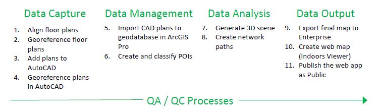
DATA CAPTURE
The SAIT team imported the PDFs of the building floor plan into ArcGIS Pro and then digitized area polygons to represent various sections of the building. The digitized polygons were then used to clip sections of the floor plan (on both levels) into PNG image outputs.
The PNG image outputs were imported into AutoCAD where they were georeferenced and used to help put the whole building floor plan together. The team chose to use AutoCAD for this task since the tools allow for a very high level of precision. In AutoCAD, the team digitized all external walls, interior walls, doors and pathways (including stairs and elevators). The resulting data was exported as CAD features.
DATA MANAGEMENT
The CAD features were then imported in geodatabase feature classes for ArcGIS Indoors in ArcGIS Pro. The team noted that there were several attribute fields common to each feature class that needed to have exactly the same values throughout the data transformation process, otherwise this would lead to cascading errors later on in the process. For this reason, QA/QC processes took place throughout the project. The team realized that they needed to have almost perfect data to start with to have a very good result in the end.
The final geodatabase contained all feature classes used to create the final ArcGIS Indoors dataset.
DATA ANALYSIS
The geodatabase feature classes were then used as input parameters for the geoprocessing tool “Generating Indoors Pathways.” One of the feature classes used was “Restricted_Areas” which represented areas of the Centre that users would not navigate through such as ice rinks, courts, pools, open-air areas on the second level, etc. These areas were omitted from the final output.
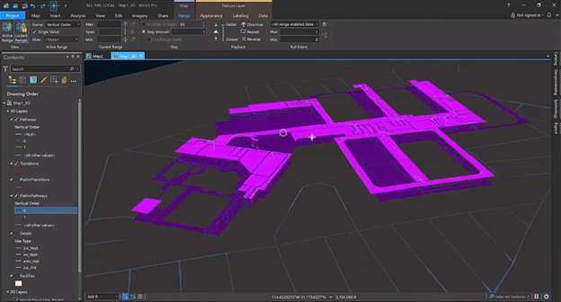
Vertical floor transitions between the first and second floor of the building were then generated using the tool “Generate Floor Transitions.” This allowed the network to be applied in a 3D environment. An interesting note about this tool is that an “Elevator Delay” time limit was applied to represent the time it would take for users to ride the elevators.
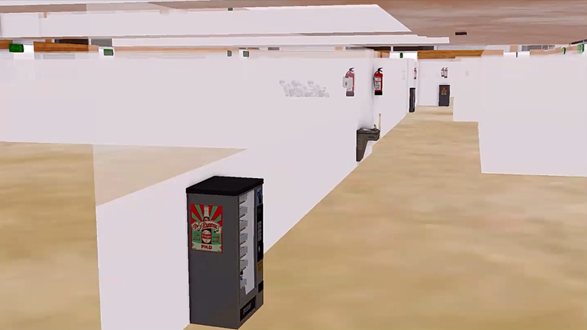
Transitions and pathways were output from this tool, as shown in the figure below. The generated pathways included all possible pathways in the building in the form of a track lattice, with nodes placed every 90 cm. The transition data was output as straight lines which the team manually curved around objects like staircases.
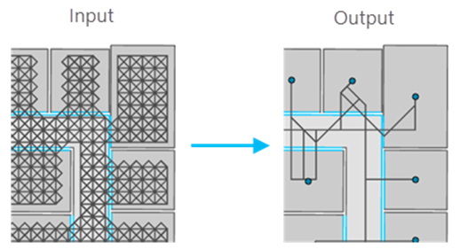
The pathways were then thinned to produce only the pathways connecting the POIs using the geoprocessing tool “Thin Indoor Pathways.” The output generated from this tool was similar to the example shown below.
Finally, the service areas that resulted from running the “Thin Indoor Pathways” tool were tested. To do this, the team selected all pathway and transition outputs from the tool, then ran the test from the “Network Analyst” toolset in ArcGIS Pro. Once this was done, the team performed more QA/QC steps by checking that each area of the building was connected to the network.
DATA OUTPUT
With the final dataset created and QC’d, it could now be published to ArcGIS Enterprise. The Network Dataset was shared using the “Share As Web Layer” tool where it could be made available through ArcGIS Online. The team also published a web map and Mobile Map Package of all the POIs, details, facilities, units and levels. Once the datasets were published, their sharing settings were changed to “Public” so the data could be used by guests of the web and mobile applications.
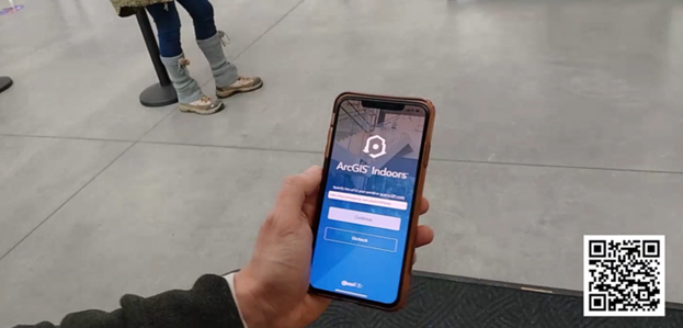
The team then made a trip to the Centre to test out their data using the ArcGIS Indoors mobile app, where they found that they could go from any origin to any destination in the building. The team was able to follow their position in the building from the app to various destinations, and the app even allowed for voice-activated route navigation. One thing the team noted was that location accuracy could be improved by implementing an indoor positioning system (IPS), which would survey the building and create positioning data via Wi-Fi access points and Bluetooth beacons.
Lessons Learned
The SAIT team learned several lessons throughout this project:
- Data Projections– A Web Mercator projection was eventually chosen over other projections because Web Mercator works very well in web applications.
- Constant feedback and support – Receiving constant feedback and support from project stakeholders greatly enhanced the final output.
- Continual QA/QC processes – Troubleshooting took a great deal of time and effort because if data was misconfigured in the slightest way, this had ripple effects throughout the rest of the steps.
- Take advantage of readily available resources –Esri web tutorials turned out to be very helpful. The team learned that they didn’t need to reinvent the wheel, just realign it for their work.
- The GIS cycle is not time balanced – The four main areas of work were not split equally in terms of time. The Data Capture step for instance took about 60% of the project time, while the other three steps were divided roughly equally.
Conclusion
The SAIT team presented their work to project stakeholders in April 2021 and received an A+ in their class. The BGIS capstone project effectively gave the SAIT students the opportunity to apply their knowledge and skills learned in the classroom to a real-world situation, and gain valuable work experience with members of industry and industry-leading GIS technologies.
MNC was grateful for the opportunity to participate as capstone mentor and would like to thank the SAIT students and faculty, and the team from the Spray Lake Sawmills Family Sports Centre for their participation in this project.
Links of Interest
SAIT BGIS Program
Esri Indoors Mapping Overview
LinkedIn Profile for Kristine-Daniela Sheperdson
LinkedIn Profile for Luis Gonzalez Garcia
LinkedIn Profile for Luisa Trevisan Ribeiro