
Watch as MNC creates the authoritative map of all surveyed land parcels in Alberta.
The Alberta Township System (ATS) is the foundational land grid used to describe and locate parcels of land throughout the province. In 2005, the ATS mapping dataset was upgraded to Version 4.1 through a collaborative project led by MNC (Martin Newby Consulting Ltd.) and Alberta Data Partnerships Ltd. (ADP) on behalf of the Government of Alberta. The primary objective of this project was to synchronize the digital township grid with Alberta’s evolving cadastral fabric, the authoritative map of all surveyed land parcels.
By doing so, it ensured that all land descriptions and regulatory submissions were aligned with the most current and accurate spatial data available.
This initiative improved spatial consistency across systems used by municipalities, surveyors, and land administrators, enhancing accuracy and providing a stronger foundation for decision-making across planning, land development, and regulatory functions.
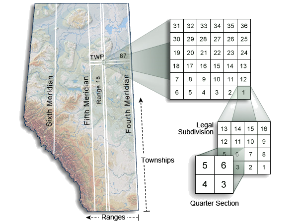
As GPS technology became standard practice for surveyors, it provided highly accurate and consistent locations for ATS corners and land parcels. This greater accuracy exposed mismatches between the existing ATS grid and the precise locations being collected on the ground using GPS. Because of these mismatches, it became essential to update more precisely with the Cadastral base.
These inconsistencies created challenges for municipalities, utility companies, and surveyors who relied on accurate spatial data for land use planning, regulatory compliance, and infrastructure development.
Misalignment between ATS corner coordinates and cadastral parcel boundaries.
Reduced accuracy in land location descriptions affecting legal, planning, and regulatory processes.
Difficulty integrating modern GPS survey data with existing mapping products.
Lack of a single authoritative grid standard for land-related submissions across Alberta.
To address these issues, the Government of Alberta mandated the use of ATS Version 4.1 as the regulatory standard for all lease applications on Crown land. This required a comprehensive update and correction of the township grid to ensure province-wide consistency and improve the reliability of spatial data.
Click the download button to download
a PDF version of this Use Case.
MNC led a comprehensive upgrade of the Alberta Township System to resolve discrepancies and establish a reliable, province-wide standard. The project began with a detailed assessment of the existing ATS framework and its alignment with Alberta’s cadastral fabric.
Conducted a province-wide analysis to identify and quantify coordinate differences between the ATS grid and the maintained cadastral mapping.
Created and published a new, standardized ATS grid that resolved known discrepancies.
Aligned the grid precisely with Alberta’s cadastral base using industry-standard geospatial tools.
Used MicroStation (Bentley) and ArcGIS (Esri) to generate the updated ATS Version 4.1 grid.
Developed GIS-ready polygon layers representing township boundaries. These were derived from the updated Master ATS point file and clipped to match the provincial boundary.
ATS Version 4.1 was formally mandated by the Government of Alberta as the regulatory submission standard, ensuring consistent use across sectors.
Through this initiative, MNC produced a definitive township grid that aligned spatial data used for legal land descriptions with modern mapping practices, supporting more accurate and efficient land administration.
Synchronization of ATS Version 4.1 with the cadastral fabric eliminated key coordinate discrepancies.
Created a reliable set of township boundaries used widely in GIS and CAD applications across municipalities, industry, and government.
Establishing ATS Version 4.1 as the regulatory submission standard ensured province-wide consistency and reduced errors in land-related workflows.
Led by MNC, the Alberta Township System upgrade delivered lasting improvements in the accuracy, reliability, and regulatory compliance of Alberta’s land management system. It continues to serve as a critical spatial reference framework for planning, development, and governance across the province.
COVERAGE
TOWNSHIP GRID SYSTEM
AND DATA ALIGNMENT
MNC is a trusted leader in cadastral and parcel management with 25+ years of experience delivering GeoAI-ready datasets, modernizing parcel fabrics, and automating GIS workflows. As an Esri Gold and Cornerstone Partner with Parcel Management and State and Local Government Specialties, MNC provides scalable advanced GIS, ArcGIS Pro, FME automation, MicroStation, AutoCAD and cloud-ready geospatial systems that improve data quality and support government land administration modernization across Canada, the USA, and the Caribbean.